130 mile mountain trip turned into 180 mile success!

My Nissan Leaf Forum

Help Support My Nissan Leaf Forum:

This site may earn a commission from merchant affiliate links, including eBay, Amazon, and others.

IssacZachary

Well-known member
Joined
Jan 13, 2017
Messages
881
Location
Gunnison, CO, USA
From my home in Gunnison to Montrose and back which is 63.4miles one way between chargers. I have a 4685ft climb and a 6,542ft decent one way also. That makes a total of 11,227ft climb and decent over a stretch of 126.8 miles. Most of the road is barren, no homes on either side along the way, except along the reservoir and then in the small town of Cimarron. No cell phone service either until I roll into Montrose (if I make it). I'll charge back up to 100% in Montrose before heading back. The temperature right now is 22°F.

I'm very nervous, and am having doubts about this trip. My plan is to go slow from the start. In the 40mph zones through the mountains and canyons that shouldn't be hard to do. But there's a 65mph zone out of Gunnison and another coming into Montrose. I'll do my best to go 40mph max and still let traffic by until I'm close to Montrose, or Gunnison on the way back, as long as I have enough charge to do so. Most of the road is only a two lane highway, and very narrow in places. There are a few passing lanes on the uphill sections. The trip back should be the hardest since I'll be climbing more. If all goes well, I'm going to try do go to Delta this weekend.

BTW, I'm bringing my wife along.

2013 Leaf with 12 capacity bars. No LeafSpy (sorry).
 
Get AAA in case. :lol:

Going uphill is tough on efficiency, and going downhill does not recoup what is lost. To extend my range I always coast downhill in neutral, and use the regen to slow down.
 
IssacZachary said:
From my home in Gunnison to Montrose and back which is 63.4miles one way between chargers. I have a 4685ft climb and a 6,542ft decent one way also. That makes a total of 11,227ft climb and decent over a stretch of 126.8 miles. ..

The temperature right now is 22°F.

I'm very nervous, and am having doubts about this trip. My plan is to go slow from the start...

2013 Leaf with 12 capacity bars...
Drive slowly and dress warmly...

Sounds like an easy trip on a warm day, but what temperatures are you expecting during the drive, and how cold-tolerant are you and your Wife?

For comparison, see:

edatoakrun said:
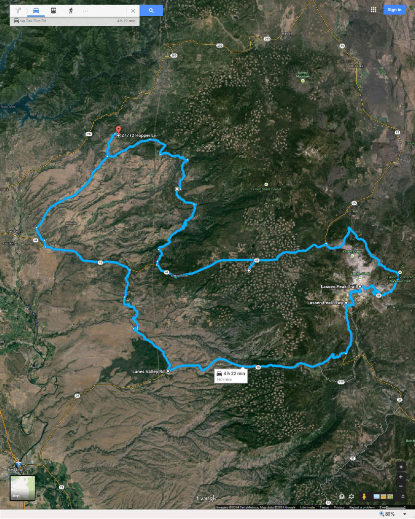
Lassen Peak trip

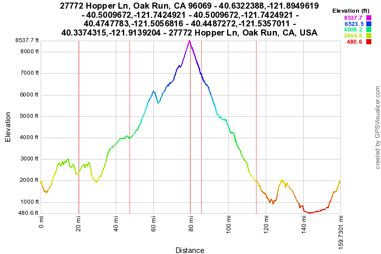
...I made three trips to the Peak trailhead last Summer (recharging at ~mile 47, the second red line on the profile) the last two times returning Via highway 36:


HWY 36 is actually easier to drive efficiently (that is-slowly) than HWY 44, as it has no 65 mph zones and more passing opportunities...

I drove my route the first time in 5 H 47 m total drive time (as compared to the
Google 4 h 22 m, and add another ~ 5 minutes to that for the ~0.7 m of my driveway off the map) estimate.

Not knowing some of the route, I drove much too slowly, and got the LBW less than a mile from home.

The second trip, cooler temperatures, on nearly new tires (both reducing efficiency) I made it in 5 H 32 m, arriving at my door well before the VLBW, as per plan.

112+ miles on a single charge is much easier, when you recharge above your destination, and have ~2,000 ft. worth of (potential) energy backing up your battery! ...
http://www.mynissanleaf.com/viewtopic.php?f=31&t=5022&start=10

"IssacZachary"... 2013 Leaf with 12 capacity bars. No LeafSpy (sorry).
You're probably better off without LeafSpy.

I drove ~the same trip, of between 160 to 161 miles total and with total ascent and descent between 13,400 and 13,600 ft. described above twice last Summer in my nine-bar 2011 with over 45 k miles without ever seeing the VLBW, after getting the LBW at the summit both times, over 80 miles from my destination.

If I had made the mistake of taking my LBC (Dash and LeafSpy) reports of capacity remaining seriously, I would have been "very nervous" too...
 
I have seen a video where someone in England climbed the highest mountain in the country and drove downhill on the other side an equal amount of elevation.... I don't know how, but they ended with the battery at the same level they started with. So the trip ended up FREE (electrically speaking).. I am surprised that the downhill portion of your trip does not significantly recharge or gives you a free ride without discharging your battery...

Here.. I found the youtube video...

https://www.youtube.com/watch?v=a6CkiYN_Rjg
 
You will regain a lot of what you use going up when you descend .. but not all, particularly if the descent requires braking.

An important detail to consider though is where the ascents are in the trip -- the closer to the middle of the route, the less taxing.
As an example, I drive our LEAF 45 miles each way to a neighboring town. A 2000 ft ascent is 2/3rds of the way distant when in the to: direction and 1/3rd distant when I return. I use up to 15 kWh going, and 12 kWh on the return. My 24 kWh battery is in excellent shape, and I found that charging to 80% was borderline. You are going 40% farther and have an ascent twice as high

So, you need to calculate kWh to the furthest climb (in either direction!) and then the kWh to climb
Climbing is estimated by M*G*H = Joules,
Where M = 1500 Kg plus the mass passengers and luggage
G = 9.8
H = climb in meters.

Sounds to me like you better have a back-up plan. I have serious doubts you are going to make it.

Addendum: the ~ 4500 feet climb requires ~ 7 kWh. Change your plans.
 
SageBrush said:
You will regain a lot of what you use going up when you descend .. but not all, particularly if the descent requires braking.

An important detail to consider though is where the ascents are in the trip -- the closer to the middle of the route, the less taxing.
As an example, I drive our LEAF 45 miles each way to a neighboring town. A 2000 ft ascent is 2/3rds of the way distant when in the to: direction and 1/3rd distant when I return. I use up to 15 kWh going, and 12 kWh on the return. My 24 kWh battery is in excellent shape, and I found that charging to 80% was borderline. You are going 40% farther and have an ascent twice as high

So, you need to calculate kWh to the furthest climb (in either direction!) and then the kWh to climb
Climbing is estimated by M*G*H = Joules,
Where M = 1500 Kg plus the mass passengers and luggage
G = 9.8
H = climb in meters.

Sounds to me like you better have a back-up plan. I have serious doubts you are going to make it.

Addendum: the ~ 4500 feet climb requires ~ 7 kWh. Change your plans.

Thanks! I love math, but never seem to be good at it. This is the total up and down. Actually I hit three peaks.

The backup plans are called brother with pickup and AAA.
 
Look at this schematic for an idea how to calculate mountain climbs:
http://docs.google.com/uc?id=mL8aj3pLC4EiHi3q7

Sorry -- link is broken. I'll fix it later
 
IssacZachary said:
SageBrush said:
Look at this schematic for an idea how to calculate mountain climbs:
https://docs.google.com/uc?id=mL8aj3pLC4EiHi3q7

The link isn't working for me.
Yeah ... sorry.

I do not have time now, I'll fix it later
 
Well folks, I chickened out. Actually I ended up needing to use the Leaf this morning. So by the time it was time to go it didn't have a full charge. So after looking at over $60 for a one day rental I decided to just go in the Golf.
 
You have to get over every peak.
While not exact, the distances can be travel distances to each peak on the road rather than the horizontal distances.
I use 4.5 miles/kWh for the travel distance and 0.5 kWh for every 300 feet climb for each net ascent*.
This gives a little margin, but ignores wind, brakes, and presumes AC and heating are off.

Remember to calculate each direction for return trips!

*By net ascent I mean the elevation change from last charge to the top of each ascent.


uc
 
SageBrush said:
You have to get over every peak.
While not exact, the distances can be travel distances to each peak on the road rather than the horizontal distances.
I use 4.5 miles/kWh for the travel distance and 0.5 kWh for every 300 feet climb for each net ascent*.
This gives a little margin, but ignores wind, brakes, and presumes AC and heating are off.

Remember to calculate each direction for return trips!

*By net ascent I mean the elevation change from last charge to the top of each ascent.


uc

Just some quick calculating. On the return I'd use some 10.5kWh all together just for the climb. That would leave me with a range of 50 miles, if I had a perfectly new battery. So I wouldn't make it, unless I could increase my kWh per mile by going 30mph. Even then I wouldn't make it.

But I didn't account for any downhill gains.
 
An example of how this works (refer to the drawing for reference):

D1: 10 miles
H1: 900 feet

D2: 20 miles
H2: 450 feet

D3: 30 miles
H3: 1500 feet

D4: 40 miles
H4: 900 feet

To reach H1 peak, you need (10/4.5 + 0.5*900/300) kWh
To reach H2 peak, you need (20/4.5 + 0.5*450/300) kWh
To reach H3 peak, you need (30/4.5 + 0.5*1500/300) kWh
To reach H4 peak, you need (40/4.5 + 0.5*900/300) kWh

This is an idealized calculation, so if you are within 10% of battery capacity, fuggetaboutit!
And remember, no wind, no brakes, no AC and no heating.
 
The EV trip planner is really easy to use:

https://www.evtripplanner.com/planner

I'm wondering, though, if that site gives accurate results or not.

Sorry for hijacking the thread a bit, but it's somewhat relevant - or would have been if the trip had actually been made ;)
 
By the way, Google maps has an elevation feature buried in the bicycle route option.
Your can identify the exact places where the elevations are highest and know the distances to those points along the trip. This is done by placing the cursor anywhere on the route; the elevation schematic shows you where you are. Right mouse-click on any points on the route to set mid-point destinations that detail distances traveled in the directions summary.

So e.g. in the trip from Gunnison to Montrose the worse climb is 36.6 miles from the origin when you have to climb 2870 net feet
Using the calcs I mentioned earlier,
36.6/4.5 = 8.1 kWh
0.5*2870/300 = 4.9 kwh
You probably (probably) make it.
Addendum: I think I reversed the origin point.

But the net climb into Gunnison from Montrose is about 1900 feet and 65 miles away. This requires
65/4.5 = 14.5 kWh
0.5*1900/300 =3.16 kWh
That 18 kWh total is just too close

uc
 
Back
Top